GFT-avenue at IABR 2014

The project GFT avenue (by Merten Nefs, Janneska Spoelman and Lucia Dossin) was nominated in the multi-disciplinary design competition Designing with Flows (Ontwerpen met Stromen). GFT-avenue proposes to increase local recycling of food and other organic material near centres of consumption in central Rotterdam, hereby cutting transport kilometres and stimulating urban agriculture.
The competition is organized by the Dutch Architect’s Association (BNA) and the International Architecture Biennale of Rotterdam, where the three nominee projects will be displayed. The winner will be anounced in June 2014, during the Biennale, which carries the theme Urban by Nature.

Hutong – a new model for Beijing?

When China opened up and became a socialist market economy, it didn’t take long for the real estate sector to emerge and start developing the contemporary Chinese city according to the logic of capital, demand and supply. Even while many companies are still state-owned. For years, the traditional alleyway neighborhoods of central Beijing, called Hutongs, were a playing ground for profitable big scale redevelopment projects, tabula-rasa style. At some point, however, residents and critics became aware of the economic and cultural value of the small-scale homes in the Hutong, leading to long and difficult recompensation processes.

Dashilar Project

During Beijing Design Week 2013 I visited the Dashilar Hutong, and later that week a few other expamples. Professor Wu Chen, also director of the Beijing Institute for Architectural Design (BIAD), presented the transformation process of Dashilar, a very central and traditional hutong, close to Tian´anmen square. Earlier that day, Jia Rong of the Dashilar Project had given us a tour. The neighborhood is to a large extent made up of one and two-storey buildings from the Ming en Qing dynasty era, with the typical structure of courtyards. The complex property situation (leases, land use rights etc.), restrictions to building heights and costly expropriation arrangements have turned Dashilar into an area that is hard to redevelop at a profit by the (state) development companies. At the same time, developments are required, since the infrastructure, sanitation and public space in the area are precarious.

dashilar05dashilar03
Dashilar Hutong (left) and Nanluoguxiang Hutong (right), Beijing

Therefore BIAD has been working for years already on an alternative development strategy. Among other measures to make people concious about the cultural value of the area, the Dashilar Phone-App was developed, through which tourists and visitors can easily explore the labyrinthic hutong and constantly receive information about design galleries, restaurants and other features in the streets of Dashilar. In collaboration with local investors, a shopping center with housing on top is being realized, avoiding the standard ‘closed box’ typology. At the same time, the infrastructure is enhanced. A new public toilet is under construction, since many of the small dwellings don’t have their own toilet. Professor Wu summarizes the project as ´Nodal development´ as opposed to the modernistic ´Tabula Rasa´ development.

dashilar06
Vertical hutong project, by Steven Holl, Beijing

The permeable hutong-model with its narrow alleys was abandoned by the upcoming middle class in the 1980’s and 1990’s. The old and precarious structures – many times without a proper bathroom or connection to water and the sewage system – were easily changed for modern appartments in superblock tower buildings beyond the 3rd ringroads of Beijing. The hutong, however, is making a comeback. The new generation likes going to famous hutongs for leisure. The centrality and function mix of many hutongs have become much appreciated, since Beijing now suffers from massive traffic infarcts and monofunctional suburbanization. Architects like Steven Holl and Riken Yamamoto have realized housing complexes in Beijing, conceived as modern, vertical, hutongs. In their project Meta:Hutongs, architects Wang Shuo and Andrew Bryant organize workshops to explore the possiblities of the hutong model, without taking sides of either the preservationists or the demolitionists. It is one of the projects featured in the Abitare China #34, a special magazine on Hutong Adaptation.

Abitare - Meta:Hutongs

The hutongs in the central area of Beijng (within the 3rd ringroad) can easily be explored in three dimensions using Baidu Maps:

SprintCity – international application

SprintCity, a planning support tool for Transit-Oriented Development, has been succesfully applied to cases in The Netherlands. Recently there is a growing interest to apply this tool in other parts of the world, to support policy makers and transit companies in optimizing transport corridors, and help researchers in exploring the mechanisms behind TOD. SprintCity has been developed over the last 4 years by the Deltametropolis Association, Delft University of Technology and Movares. Its prototype version was made possible by the Next Generation Infrastructures foundation. The English version was launched in September 2013.

SprintCity_concept

SprintCity aims
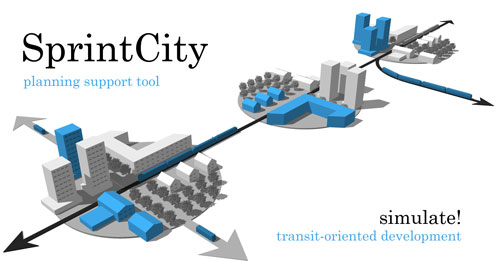
Planning support tool SprintCity simulates urban growth and train frequencies along a rail corridor, over a period of 20 years. The purpose of the tool is to give decision-makers insight into the relationship of spatial development and infrastructure, competition between municipalities and the specific qualities and opportunities of each station on a corridor. It also provides a safe platform to experiment with development strategies and collaboration between the different stakeholders.
Transit-Oriented Development (TOD) is a promising urban model for densely populated areas, such as the Netherlands. The complexity of spatial planning and transport integration, as well as the fact that there is not a single responsible authority for TOD, is causing the current suboptimal use of rail infrastructure in The Netherlands. SprintCity was developed to help break these barriers.
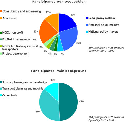
SprintCity has been used by more than 350 people, in more than 40 sessions, since 2009. It has been applied on 4 rail corridors in The Netherlands and implementation in Belgium is currently being studied. In principle, it can be used on any transport corridor (including Bus Rapid Transit), both existing corridors with existing and new stations, as well as new corridors or comparative corridor alternatives. Especially these latter applications may be relevant for metropolitan areas in developing countries.

sprintcity_users

Working on an international basis
From the beginning, SprintCity (‘SprintStad’ in Dutch) has been a collaborative project, involving universities, government bodies and private enterprises. This approach has resulted in a user-friendly and widely tested tool: SprintCity v2.0. We believe that the application and further development of SprintCity should occur internationally. On the one hand, several entities abroad have contacted us to learn about this possibility. Consequently an English version is now being developed for this new group of international users. And on the other hand, co-development on an international scale will no doubt enhance the functionalities and applications of the next versions of SprintCity.

sprintcity_haarlem
SprintCity session in Haarlem (The Netherlands)

In this manner, the growing SprintCity community will be able to learn from each new experience and from the different policy- and development contexts worldwide. The source code of SprintCity is owned by the project partners, listed above. The data input and results, however, are always shared and made public. At this point, we are engaged with experts and government bodies in the following countries: Flanders (Belgium), Sweden, India, China, Brazil, Turkey, Australia and Peru. Read more about application in these countries here.

SprintCity_Bangalore
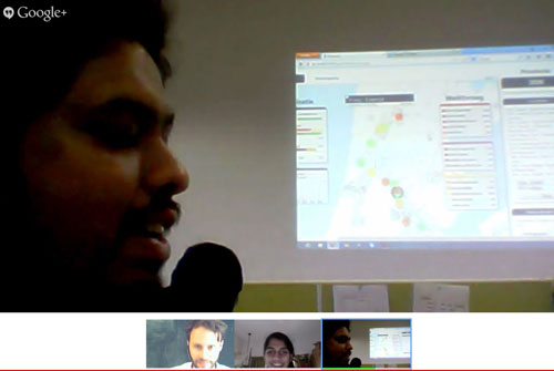
Session in Bangalore and New Delhi

SprintCity, the format
In order to include human decision making in the simulation, SprintCity has the format of a role playing game (ideally played by the real stakeholders), supported by a computer model with realistic data input. It features three types of players:

1. The Province/Region-player controls the overall development of the corridor, and needs to find an optimal location for regional functions, such as a hospital or educational facility;

2. The Transport-player controls the time table of the rail services on the corridor, and aims to increase ridership while running a profitable service;

3. The Municipality-players control the land use plans of each station area, and aspire to develop these areas according to previously chosen ambitions and a master plan.

Available train capacity, phased development areas and limited market demand for housing, offices and amenities provide natural bounderies to the system.

Read SprintCity Update #5 (English pdf), or
watch the introduction video below:

Beijing Design Week 2013

During the Beijing Design Week 2013, architecture studio Venhoeven CS organized a workshop called ‘The Sino-Dutch Approach‘, commissioned by the Creative Industry Fund. This year, Amsterdam is guest city of the BJDW. In a group of 12 Dutch designers I travelled to Beijing to work on transformation strategies for the Fengtai industrial district, in the Southwest periphery of Beijing. The aim of the workshop is to generate crossover concepts with our Chinese counterparts, for sustainable development in the capital city. Many of China’s major challenges are found in Fengtai: air quality, water management, congestion, economic shift from production to services, migration and gentrification. The district has the potential to become a creative subcentre and gateway to Beijing.

Case 1: Dahongmen
The Dahongmen area consists of fashion wholesale complexes. There are plans for fashion retail zones, focusing on the exclusive brands. The challenge here is to develop the entire value chain, from production and creation to the consumer, in order to attract and maintain a variety of professionals and social groups in the area, necessary for an innovative environment where Chinese brands and trends can emerge.

Case 2: Yongding river
Beijing has a dramatic relationship with water. On the one hand there is so much water shortage that water is brought in from the Yangtse river in the South. The Gobi desert is approaching and the Yongding river itself is dry most time of the year due to dams and water usage upstream. On the other hand heavy rainfall has caused severe damage to the urban structures in Beijing, for lack of permeable surfaces. A new type of green living environment may revive the Yongding river floodplains and redirect rainwater to feed the river.

Case 3: Fengtai railway station
The new high-speed railway station and subway links will strengthen the position of Fengtai as gateway of Beijing. Passengers traveling from Hong Kong and Shenzhen to Beijing will pass through the area. The station surroundings therefore have the potential to become a hotspot of activities and meetings, that may function in a complementary way to alleviate the congested central area of Beijing. Rather than redeveloping the whole area, a stepwise strategy could provide a lively area of reused industrial buildings, bike and pedestrian routes, densified ‘hutongs‘ and function mix of housing with amenities and work spaces.

Fengtai station strategy
Development proposal for Fengtai station area

Smart City
The main exhibition of the Design Week is about Smart Cities, held in the China Millennium Monument Museum of Digital Arts. Curated by Lei Yang, it features many tools to use big data and new media to plan and enhance the city, such as Urban OS and OS City. The SprintCity planning support tool may also provide opportunities for cities like Beijing.
The irony is however, that at the moment the Chinese authorities do not give access to urban data and have to a large extent control over what happens at the Chinese social media. This prevents civilians from using and improving many of the smart tools.

Download the presentation of the Sino-Dutch Approach, by Ton Venhoeven.
Also read the daily reports by the Creative Industry Fund, and my travel journal (Dutch), including the names of all participants.