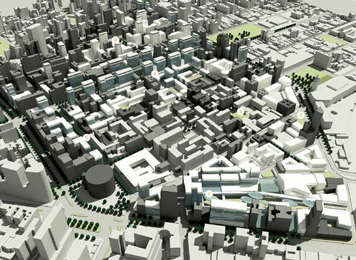
This month the urban plan for Nova Luz was presented. The plan encompasses the transformation of a large area (45 urban blocks, occupying 50 ha) close to the Luz railway station in central São Paulo. In the last decade, preparations for this plan have been made by the Municipality, including the construction of concert hall Sala São Paulo, recent plans for a new Opera designed by architects Herzog & de Meuron, and the polemic cleansing of ‘Cracolândia‘, an area dominated by drug traffic. In 2010 the city launched a tender for the urban plan of Nova Luz, which was won by a joint venture of Concremat Engenharia, Cia. City, Aecom Technology Corporation e Fundação Getúlio Vargas (FGV). In the next phases of Nova Luz, investors will need to be found to develop the individual lots. Due to the recent building boom in São Paulo, expectations are high.

A number of goals were set by the Municipality to be achieved in the plan:
– Reinforce the existing commercial function of the region, with special attention for the technology sector, represented by businesses around Rua Santa Ifigênia;
– Diversify residential profiles (different family types, singles etc.), in order to create a heterogeneous environment;
– Restore degraded and obsolete areas to increase living quality;
– Increase the amount of public space used for squares and social interaction;
– Improve the general conditions of mobility and infrastructure of the region;
– Restore architectural heritage, cultural and artistic works in the area;
– Create a social environment that promotes social and economic development.


New profile of Avenida Rio Branco
The winning project presupposes the redevelopment of around two thirds of the existing buildings, whereas one third is to be maintained and restored. The plan divides the area into five sectors:
1. Nébias – reinforcing the existing residential and hotel functions;
2. Corridor Rio Branco – turning the somewhat fragmented avenue into a dense urban boulevard, served by public transport, with large office buildings on top of a retail base level;
3. Triunfo – creating a diverse residential area, with library, school, kinder-garden and services;
4. Nova Luz Culture and Entertainment area – transforms the direct surroundings of the station, mainly sheds and parking lots, into a leisure area;
5. Technological area – attracting lead technology businesses through tax incentives.

Triunfo sector – school and public space
Architectonic ambitions are high, judging by the illustrations of the plan. Buildings interact with the urban environment at ground level and have lively balconies and openings in the facades. Public space is very green and attractive, compared to earlier urban operations in the city such as the Berrini Avenue. A few observations have to be made:
Firstly, the project merely provides volumetric studies of the area and does not determine the exact urban form of the developments at this stage. Individual developers will offer their projects in following tenders. In the past, this has not always led to a desirable urban form and architectural quality in São Paulo. Developers tend to emphasize safety and privacy aspects, instead of interaction of the building with the street, as they fear that the building won’t sell if it is made too transparent and accessible. If investors don’t commit to the architectural ambitions of the urban plan, or when supervision of the plan fails, the quality of the whole plan is at stake.
Secondly, the quota of social housing units in the plan, as fixed in the Zeis municipal land use plan, must still be implemented through tenders. As this segment is less profitable than other types of dwellings, the social housing units tends to be unattractive for investors. Strict rules for mixed developments and application of fines when social housing is not delivered, could help to encourage the fast implementation of social housing in the area.

Sala São Paulo concert hall by night
Many of the buildings on the list to be demolished, have a social housing function today. NGO’s like Fórum Centro Vivo have been concerned with the current population and small businesses in the Nova Luz area, threatened by increasing real estate values and gentrification. In 2008, the NGO organized an informal night walk through Nova Luz with lanterns, Traga sua Luz, to point out the effects of demolishing in the area. Less than two years later, the offical Nova Luz project office organizes another night walk to show the beauty and potential of the cultural district, near the Luz train station. However, the photo report of the excursion shows mostly well known historic buildings situated outside the Nova Luz area, such as Teatro Municipal.
Read more:
Nova Luz SP project office
Nova Cracolândia (Portuguese)
Nova Luz in 2007 (Portuguese)


