Atlanta BeltLine – lecture, debate and booklet

The Atlanta Beltline combines the development of a new light rail connection on an abandoned cargo track with adjacent developments of housing, parks and public facilities. The project is marked by the strikingly effective cooperation between volunteering community members, real estate developers and the government. Intrigued by the project, the Deltametropolis Association invited Ryan Gravel (Perkins+Will), initiator of the project, to give a lecture and discuss Transit Oriented Development (TOD) with other experts. This program was part of the SprintCity project, led by Merten Nefs, which investigates opportunities for TOD in the Netherlands.
Gravel has been the driving force behind the Atlanta BeltLine since the beginning. When he graduated on the project at Georgia Tech university 12 years ago, no one could imagine that it would become a billion dollar urban development. Currently, he works on the BeltLine corridor design, as an urban planner at the Perkins+Will office.

Download the booklet on the Atlanta BeltLine and Gravel’s vision on Transit Oriented Development in Randstad Holand.


Open publication
– Free publishing

View the lecture, given October 6, 2011 at Delft University of Technology

After the lecture, a discussion was held with Caroline Bos, Dominic Stead and Paul Gerretsen. The lecture was co-organized by Roberto Rocco (TUDelft).

View the debate after the lecture

The following day, Friday October 7, SprintCity also organized an interactive video debate on international practices of Transit Oriented Development: ‘Station to City’. This debate was part of the Architecture Film Festival Rotterdam (AFFR). Three continents were introduced by a keynote speaker:

> The American Way – Ryan Gravel (Perkins+Will)
Creating pockets of urban areas with public transportation in a  car-oriented  country     

> The Asian Way – Slavis Poczebutas (OMA)
Intense integration of urban development, lifestyle and public transport

> The European Way – Sebastiaan de Wilde (NS Dutch Railways)
New policies for increasing public transport use

Read more and view the featured videos on international TOD cases
Download the complete program of the event
Download SprintStad Update #4

Luz – Left Hand Rotation

In the last couple of years, project Nova Luz has begun to transform one of the liveliest and most central parts of São Paulo. Low income groups fear they will have to leave the area soon, due to expropriation, demolition and gentrification. Questions are raised regarding the inclusion of these social groups in the urban plan. Spanish media collective Left Hand Rotation recently launched a documentary on this topic (Portuguese/Spanish).

Nos últimos anos, o projeto Nova Luz começou a transformar um dos bairros mais centrais e movimentados de São Paulo. Moradores de baixa renda são expostas á desapropriação, demolição e gentrificação, processos que acabam expulsando-0s da região central. A inclusão desses grupos no projeto, na forma de zoneamento ZEIS, está sendo debatido no momento. Coletivo Espanhol Left Hand Rotation recentemente lancou um documentário sobre essa situação (Português/Espanhol).

Read more / leia mais:
Gentrification workshop Brasília (Left Hand Rotation)
The Luz District in São Paulo: Anthropological questions on the phenomenon of gentrification
Nova Luz – an update

SP aérea – Centro Novo
Traga sua Luz

Rotterdam CS – as long as it lasts

For years now the Rotterdam Central Station area is under construction. First, during demolishing of the old post-war style entrance and underground construction works for the metro link, the process was not very visible. Now things are moving fast. Not only is the main terminal approaching it’s final shape and extent above ground, there has also been very efficient communication with users and residents about the project: billboards with rendered images have been put up, interactive panorama images and time lapse films of  the construction process have been published on-line, and guided tours are being organized on the site.

The new Rotterdam CS will be a multi modal transit terminal, connecting high speed and intercity rail to local light rail, trams, buses and metro lines. Today, the station receives 110.000 passengers. With the new rail connections and growing mobility in the region, the amount of passengers in 2025 is estimated at 323.000 per day. In the 1990’s, the project was commissioned to British architect Will Alsop. His design, soon associated with ‘ champagne glasses’, turned out to be politically and economically unfeasible and was abandoned. After this attempt, Dutch architects Benthem & Crouwel were invited for the assignment. Their office is responsible for 4 other large railway stations in the Netherlands: Amsterdam CS, Utrecht CS, The Hague CS and Schiphol Plaza (Amsterdam airport). Alsop, by the way, still got the opportunity to develop a colorful building just in front of the station. In 2008, the old Rotterdam CS was demolished, soon the old bicycle and pedestrian tunnel will be demolished too. In 2013 the new terminal will be inaugurated, and in 2014 also the adjacent Kruisplein underground parking garage and square. The new canopy over the platforms will have a glass roof with embedded photovoltaic cells. The main concourse has an incredibly large span and reaches almost until the Weena avenue. A new passageway underneath the tracks is being built of almost 50m wide, including shops on both sides.

Old and new station entrance (under construction)

Construction of the Calypso building, by Alsop

Old and new platform canopy (left), and the temporary station building (right)

Interactive panorama, click to switch between various points in time

Time lapse movie of demolishing and building part of the station

Visit Rotterdam CS in Google Maps

Scheldekwartier

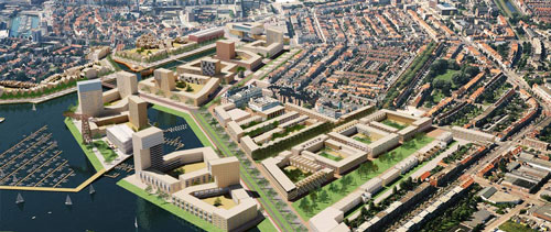
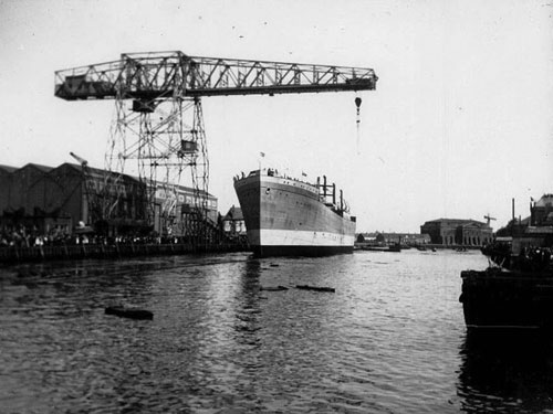
The history of Vlissingen was largely influenced by the shipyard in the centre of the city. Already in the 16th and 17th centuries, wooden vessels were made here for trade and military purposes. Once in while the shipyard expanded, demolishing part of downtown Vlissingen. In 1875 the wharf became private property and was the largest company in town in the 1950’s, with 4.600 employees. For many years the wharf carried the name Royal Schelde Group. In 2003 Damen Shipyards sold large part of the area to the Municipality to build an ambitious new housing project of 32 hectares, called Scheldekwartier. Part of the wharf will maintain its old function, for construction and maintenance of luxury yachts. The masterplan foresaw five different areas of urban development, including a marina and waterfront high-rise.

It can be questioned whether the plans could be realized in Vlissingen, with limited population growth, threat of shrinkage, and historically low real estate prices. A fact is that since the real estate crisis of 2008, the plan completely lost ground. The project developer of the first phase postponed the construction of the first houses, since it required 70% pre-sale of the housing units. Another investor was brought in to save the day. Now the first 51 units are under construction. The structure of the carpenter’s workshop has recently been restored, with help of subsidies. In general, the city has stated that the masterplan has to be adapted to the new economic reality and that ambitions should therefore be lower.  The city fears that the gigantic vacant space may turn the city unsafe and unattractive over time. Money has already been spent and profits are lower due to problems on the real estate market. The delay of the housing projects costs the Municipality milions of Euros per year of interest. So they’re obviously in a rush.

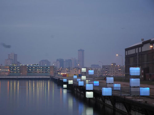
The alternative of temporary use, however, has not been deeply investigated. Some temporary artistic work is being done, such as the work by Enzo Producties. But temporary housing, small scale production or student facilities have not been planned in the area. Preparing this new part of town with temporary activities might just be the way to create a market and identity for the area, and could easily use the opportunity of the location: a waterfront between the city center and the railway station. In such a gradual development approach, ambitions may not have to be lower in the end. They can even be higher and better adapted to the future circumstances. The Municipality quickly acknowledges the need to exit the old masterplan, but at the same time does not embrace a more flexible and temporary strategy. It will certainly take some time to develop the full 32 hectares, so the chances are still there!

Visit Scheldekwartier Vlissingen on Google Maps

Read more:
History of the area (Dutch)
Alteration of the masterplan programming (Dutch)
Construction starts (Dutch)

Inventing Europe

Inventing Europe is a pioneering collaborative project in which historians and cultural heritage institutions throughout Europe together tell a new kind of history of Europe. Following the paths of technology from the transport and communication revolutions of the Nineteenth Century through to the present day, in the course of half a year the project will realize an online exhibition that shows to a wide range of users the ways technology has shaped Europe – and the ways Europe has shaped technology.
Based on research from the six-part book series Making Europe: Technology and Transformations 1850-2000 the virtual exhibit explores the broad themes of globalization, consumption, communication, infrastructures, knowledge societies, and governance. It seeks to make its results available to a wider audience by drawing on the rich and growing online collections of museums, archives and libraries throughout Europe and beyond.”

The exhibit, developed at Imperial College, London, will allow participating museums to share relevant content from their online collections quickly and easily. These appear as related content next to the objects within the exhibit, and serve as a portal for further exploration on the web. Click here to access the prototype exhibit: “Europe, Interrupted”.