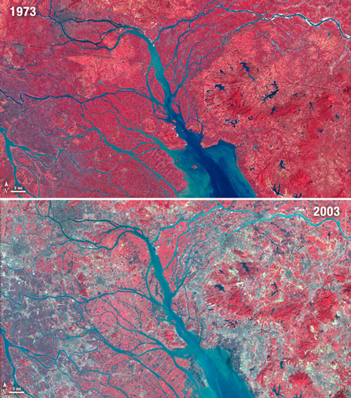
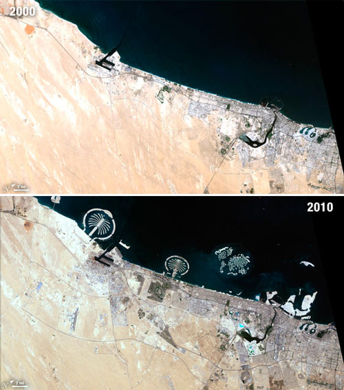
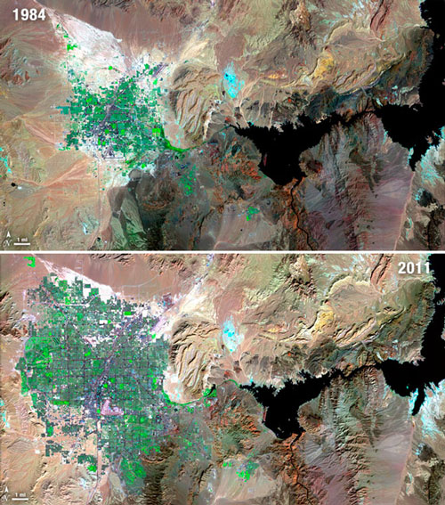
40 years of massive growth

How much have we built on the earth’s surface over the last 40 years?
Wired Science
features satellite images of urban settlements in the 1970’s and this decade, demonstrating massive urban growth.There is also a set of videos about Landsat’s most historically significant images, including the Kuwait oil well fires and Amazone deforestation.

Growth of Las Vegas

“In celebration of four decades of collection of irreplaceable data and incredible images, the Landsat team released these images of change in 11 cities and urban areas all over the world. Images courtesy of NASA and the USGS.”

Growth in the Pearl River Delta

Growth in Dubai


London olympics 2012 – inauguration

The games have begun!

After years of planning, building and preparations the Olympic Village has been inaugurated and is now fully functional. For the period after the games, a legacy plan has been drawn up. The utility of the venues, infrastructure and accommodations is to be guaranteed by downscaling of the stadiums, reuse of the hotels as apartments and further redevelopment of the East London area.

The first frustrations of the event have already floated to the surface as well:
Local residents complain about missiles and other military equipment installed on their roofs, for security purposes, while taxi drivers complain about the exclusive VIP traffic lanes, reserved for IOC personnel and sponsors. The Olympic cauldron had to be extinguished and lit again in order to move it out of the way on the opening night. And a great number of the temporary seats in the Aquatics Centre does not seem to have a clear view of the dives, due to the curved roof. Architect Zaha Hadid however is not to blame, they say, since it concerns the temporary seats and tickets should not have been sold for those seats during diving sessions. Anyway, all of these troubles will be over after the spectacle.

For the period after the games, many doubts were raised regarding the gentrification of the East London neighborhoods of the already rather hyped Hackney Wick, and the traditional working class neighborhoods Tower Hamlets and Newham. What will happen there, when the athletes are gone, remains to be seen. As yet, the Shard, now the highest tower in Europe, designed by Renzo Piano and located in Southwark, is still largely vacant. Smaller and more flexible projects are mushrooming in the Olympic area, such as the White Building, a refurbishment of an old industrial building by architect David Kohn.

The Shard building

The White Building

Does the Olympics bring sustainable developments to East London and will they bring long term jobs to this area plagued by unemployment? Will gentrification of the East lead to a less segregated London? We’ll take a look at the site again at the end of the games and see what happens.

In the mean time, have a look at ‘London’s Loss? Why Hosting the Olympics Is Bad Business’ – Time

Or take a look at the Olympic Village in Google maps:

London Games open larger map
Peri-urbanisation in Europe


A new kind of space is emerging in Europe: The Peri-urban contains the urban fringe and urban periphery and is located in between the urban and rural areas. It is here in this in-between-space that major demographic, economic and land use shifts will take place, presenting the urban regions with several challenges of sprawl, air- and spatial quality and accessibility.


The PLUREL program has done research on peri-urbanisation in 27 EU countries, on the regional level, and with 6 case studies, including Haaglanden in the Netherlands. According to PLUREL’s definition, the Randstad Holland consists almost entirely of urban and peri-urban areas. And in the top-20 of peri-urban regions in the EU-27, 9 regions are Dutch!

In the Synthesis Report (download full PDF), dynamics and driving forces of the peri-urban are discussed, as well as possible future problems and policy challenges. Peri-urban agendas are put forward regarding Economy and employment, Population and migration, Housing and community, Mobility and transport, Food and farming, Environment and landscape, Recreation and tourism, and Managing growth.

Four scenarios are used in the project:

  • High Growth (‘Hypertech’)
  • Climate Change (‘Extreme Water’)
  • Energy Crisis (‘Peak Oil’)
  • Social Fragmentation (‘Walls and enclaves’)

The report ends by setting out new concepts for urban-rural linkages and providing recommendations for targeted policies for rural-urban regions across Europe.

Flooding of the Elbe river, Germany, 2002

View over Warsaw, Poland (PLUREL case study)

Editors: Annette Piorr, Joe Ravetz, Ivan Tosics
Publisher: University of Copenhagen/Academic Books Life Sciences
(ISSN: 978-87-7903-535-5)

Köln waterfront

The riverfront is certainly one of the main urban axis of Köln (Cologne). Its main tourist attraction and landmark, the cathedral, as well as the central train station, are located close to the margins of the Rhine. The city harbor area, the Rheinauhafen, built in the 1880’s, has gone through a redevelopment process over the last decade. Based on a competition design of the 1990’s, construction on the 15 hectare site started in 2002. The middle of three ‘crane houses’ won a prize for best office development in 2009. With good weather, the walkway is a busy route for pedestrians and cyclists.

Redesigned riverfront walkway, view on railroad bridge

Köln Hauptbahnhof, staircase towards the cathedral

New residential developments at Rheinauhafen

View over the Rhine from Rheinauhafen

Walkway and ‘crane houses’

Inside MAS Antwerp

Museum aan de Stroom (MAS), meaning as much as riverside museum, is the new heart of a formal dock area and neighborhood called Eilandje (island) in Antwerp. The area went through a huge transformation over the last ten years, including intensification with apartment blocks, renovation of existing buildings and redesign of public spaces. Much of the prostitution and other remnants of the former harbor area are now gone.

The design of the museum, by Neutelings Riedijk, is marked by a public walkway that spirals its way up from the street to the roof level, giving the building its zigurat shape. This feature integrates public space with the building volume and brings visitors and neighbors in easy contact with the exhibitions. The walkway consists of spacious squares and escalators behind a curved glass curtain wall, through which different panoramas of Antwerp appear.

South view over central Antwerp

North view over harbor area and new residential developments

West view over the river Schelde and the Linkeroever (left bank)