Merged cities

Designer Leonard de Vogel produced a couple of intriguing fusions of Amsterdam with other waterfront cities. Imagine the canals of central Amsterdam with, on the horizon, the skyline of Manhattan. Or the central part of Rotterdam – north of the river Maas, combined with the central part of Amsterdam  – south of Het IJ.


Merge of New York and Amsterdam


Merge of Rotterdam and Amsterdam

SprintCity – spring 2011

SprintCity (SprintStad in Dutch) is a project by the DeltaMetropolis Association, which investigates possibilities for urbanization around public transport nodes in the Randstad region (The Netherlands). The ultimate goal is to create attractive and sustainable environments for living, leisure and working, by optimizing the use of already existing rail infrastructure. For more information on this project, click here (English).


Station on railway corridor in SprintCity

In the first semester of 2011, SprintCity has been busy:
– A new version of serious game SprintStad was launched (version 1.1); the game simulates spatial developments around trains stations until the year 2030, and was played with several stakeholders
– Presentations were given at KEI VRJRS-party, Ruimteconferentie (PBL) and soon at InfraTrends and Hogeschool Rotterdam
– An article was published in Agora Magazine (Dutch-Flemish magazine for spatial planning), describing the use of serious game SprintStad in practice
– A FactSheet was published, demonstrating potential of smaller railway stations along rail corridors included in the national plan for high-frequency train service, to be implemented until 2030
– New project partners and investors were found
Update SprintStad #3 was published, featuring news, research results and international context; the Update can be downloaded here


Simulation game session, in Amersfoort


Urban density survey of international station areas

Read more: SprintCity goes China

Spatial impact of roads

April 2011, researcher Henar Salas Olmedo obtained her PhD title in Geography and Spatial Planning at the University of Cantabria, Santander (Spain). Her thesis – THE SPATIAL IMPACT OF ROADS – discusses land use changes around heavy road infrastructure and was supervised by Dra. Soledad Nogués. Merten Nefs was asked to review and comment the thesis as external expert.

“Nowadays, transport has become an essential activity is our society. The role transport plays has such an importance that it is frequently named as a basic factor to generate
development. This document deals specifically with the effects of highways on the spatial pattern of population, firms and the hierarchy of settlements in relatively peripheral areas in the EU context, that is, not large metropolitan areas but subregional areas with some transport infrastructures with a low level of dynamism. […]
Two study areas are compared: Doncaster Metropolitan Borough, which contains two motorway crossings, and the Lincoln Policy Area, which is a crossroads for several trunk  roads. The comparative analysis and diagnosis of these areas led to some significant conclusions: the motorway-connected area shows a greater dispersion of industrial and service than residential land uses; the dispersion of residential areas in the trunk-road area starts later but with a similar, or even more intense, trend; the primate city is more and more dominant in the trunk-road area, whereas in the motorway-connected area intermediate towns are increasing their functions; and commuting flows are relatively more numerous, although shorter and spatially more concentrated, in the trunk-road area.”


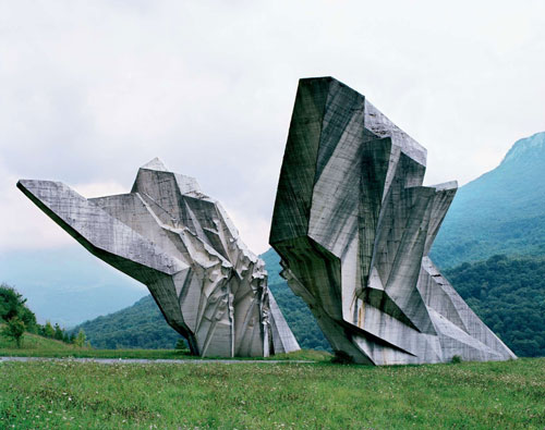
Concrete legacy

Very impressive artwork in concrete from the 1960s and 1970s in Yugoslavia, published on Crack Two. (photographs of 25 abandoned monuments)

“These structures were commissioned by former Yugoslavian president Josip Broz Tito in the 1960s and 70s to commemorate sites where WWII battles took place (like Tjentište, Kozara and Kadinjača), or where concentration camps stood (like Jasenovac and Niš). They were designed by different sculptors (Dušan Džamonja, Vojin Bakić, Miodrag Živković, Jordan and Iskra Grabul, to name a few) and architects (Bogdan Bogdanović, Gradimir Medaković…), conveying powerful visual impact to show the confidence and strength of the Socialist Republic. In the 1980s, these monuments attracted millions of visitors per year, especially young pioneers for their “patriotic education.” After the Republic dissolved in early 1990s, they were completely abandoned, and their symbolic meanings were forever lost.
From 2006 to 2009, Kempenaers toured around the ex-Yugoslavia region (now Croatia, Serbia, Slovenia, Bosnia and Herzegovina, etc.) with the help of a 1975 map of memorials, bringing before our eyes a series of melancholy yet striking images.”