Radical cartography

Radical Cartography shows the world in many aspects through a list of interesting maps. How did nuclear reactors and railways spread around the globe? Where does our food come from? Which parts of Manhattan are under-developed, according to FAR building regulations? What would a world map look like with New York in its center? And how does our routine of thinking about cities in terms of borders and districts affect our perception of ethnic neighborhoods?

‘Bill Rankin is a historian and cartographer. His mapping activity is focused on reimagining everyday urban and territorial geographies by pushing techniques of statistical information design and rethinking everyday cartographic conventions.’


The founder of Radical Cartography, Bill Rankin, got a prize for his maps on ethnic groups in American cities. It turned out that representing groups of 25 people with dots gave a much more diverse result than the classic boundary-approach of urban districts: cities are segregated, but some areas are very mixed on a local level. Traditional maps fail to show this.

Scheldekwartier

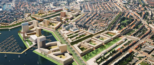
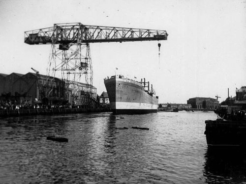
The history of Vlissingen was largely influenced by the shipyard in the centre of the city. Already in the 16th and 17th centuries, wooden vessels were made here for trade and military purposes. Once in while the shipyard expanded, demolishing part of downtown Vlissingen. In 1875 the wharf became private property and was the largest company in town in the 1950’s, with 4.600 employees. For many years the wharf carried the name Royal Schelde Group. In 2003 Damen Shipyards sold large part of the area to the Municipality to build an ambitious new housing project of 32 hectares, called Scheldekwartier. Part of the wharf will maintain its old function, for construction and maintenance of luxury yachts. The masterplan foresaw five different areas of urban development, including a marina and waterfront high-rise.

It can be questioned whether the plans could be realized in Vlissingen, with limited population growth, threat of shrinkage, and historically low real estate prices. A fact is that since the real estate crisis of 2008, the plan completely lost ground. The project developer of the first phase postponed the construction of the first houses, since it required 70% pre-sale of the housing units. Another investor was brought in to save the day. Now the first 51 units are under construction. The structure of the carpenter’s workshop has recently been restored, with help of subsidies. In general, the city has stated that the masterplan has to be adapted to the new economic reality and that ambitions should therefore be lower.  The city fears that the gigantic vacant space may turn the city unsafe and unattractive over time. Money has already been spent and profits are lower due to problems on the real estate market. The delay of the housing projects costs the Municipality milions of Euros per year of interest. So they’re obviously in a rush.
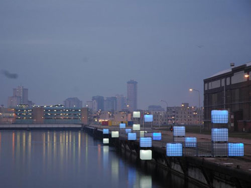
The alternative of temporary use, however, has not been deeply investigated. Some temporary artistic work is being done, such as the work by Enzo Producties. But temporary housing, small scale production or student facilities have not been planned in the area. Preparing this new part of town with temporary activities might just be the way to create a market and identity for the area, and could easily use the opportunity of the location: a waterfront between the city center and the railway station. In such a gradual development approach, ambitions may not have to be lower in the end. They can even be higher and better adapted to the future circumstances. The Municipality quickly acknowledges the need to exit the old masterplan, but at the same time does not embrace a more flexible and temporary strategy. It will certainly take some time to develop the full 32 hectares, so the chances are still there!

Visit Scheldekwartier Vlissingen on Google Maps

Read more:
History of the area (Dutch)
Alteration of the masterplan programming (Dutch)
Construction starts (Dutch)

Inventing Europe

Inventing Europe is a pioneering collaborative project in which historians and cultural heritage institutions throughout Europe together tell a new kind of history of Europe. Following the paths of technology from the transport and communication revolutions of the Nineteenth Century through to the present day, in the course of half a year the project will realize an online exhibition that shows to a wide range of users the ways technology has shaped Europe – and the ways Europe has shaped technology.
Based on research from the six-part book series Making Europe: Technology and Transformations 1850-2000 the virtual exhibit explores the broad themes of globalization, consumption, communication, infrastructures, knowledge societies, and governance. It seeks to make its results available to a wider audience by drawing on the rich and growing online collections of museums, archives and libraries throughout Europe and beyond.”

The exhibit, developed at Imperial College, London, will allow participating museums to share relevant content from their online collections quickly and easily. These appear as related content next to the objects within the exhibit, and serve as a portal for further exploration on the web. Click here to access the prototype exhibit: “Europe, Interrupted”.

‘New’ space for the city

The discussion continues on whether Amsterdam can realize urban growth within existing urban areas or whether the city needs the proposed big-scale expansion locations at the artifical island of IJburg and near the 1970’s satellite-town Almere. Architects Tom Bergevoet and Maarten van Tuijl, of Temp Architecture, did a basic survey using Google Earth and found about 450 ha of vacant lots (red stains on the map) in Amsterdam, comparable to the IJburg project. Temporary use of vacant urban space for recreation, gardening and cultural events could make urban life more pleasant and prepare new sites like IJburg for urban occupation (phased development scheme below, in three steps). Politicians agree that a certain amount of vacant land and buildings is always needed to keep a city flexible and dynamic. However, a surplus of vacancy is thought to be unpleasant and unsafe.

ARCAM organizes debates with politicians, investors and entrepreneurs, on vacant buildings (May 18th 2011), and on vacant urban land (May 25th 2011). From May 11th, ARCAM hosts an exhibition by Temp, called New Space for the City.

Read More:
Urban Change – Amsterdam: densification or expansion (English)
Het Parool – In de stad ligt een IJburg braak (Dutch)

Merged cities

Designer Leonard de Vogel produced a couple of intriguing fusions of Amsterdam with other waterfront cities. Imagine the canals of central Amsterdam with, on the horizon, the skyline of Manhattan. Or the central part of Rotterdam – north of the river Maas, combined with the central part of Amsterdam  – south of Het IJ.


Merge of New York and Amsterdam


Merge of Rotterdam and Amsterdam