Concrete legacy

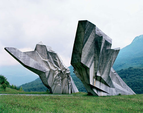
Very impressive artwork in concrete from the 1960s and 1970s in Yugoslavia, published on Crack Two. (photographs of 25 abandoned monuments)

“These structures were commissioned by former Yugoslavian president Josip Broz Tito in the 1960s and 70s to commemorate sites where WWII battles took place (like Tjentište, Kozara and Kadinjača), or where concentration camps stood (like Jasenovac and Niš). They were designed by different sculptors (Dušan Džamonja, Vojin Bakić, Miodrag Živković, Jordan and Iskra Grabul, to name a few) and architects (Bogdan Bogdanović, Gradimir Medaković…), conveying powerful visual impact to show the confidence and strength of the Socialist Republic. In the 1980s, these monuments attracted millions of visitors per year, especially young pioneers for their “patriotic education.” After the Republic dissolved in early 1990s, they were completely abandoned, and their symbolic meanings were forever lost.
From 2006 to 2009, Kempenaers toured around the ex-Yugoslavia region (now Croatia, Serbia, Slovenia, Bosnia and Herzegovina, etc.) with the help of a 1975 map of memorials, bringing before our eyes a series of melancholy yet striking images.”


Nova Luz – an update

This month the urban plan for Nova Luz was presented. The plan encompasses the transformation of a large area (45 urban blocks, occupying 50 ha) close to the Luz railway station in central São Paulo. In the last decade, preparations for this plan have been made by the Municipality, including the construction of concert hall Sala São Paulo, recent plans for a new Opera designed by architects Herzog & de Meuron, and the polemic cleansing of ‘Cracolândia‘, an area dominated by drug traffic. In 2010 the city launched a tender for the urban plan of Nova Luz, which was won by a joint venture of Concremat Engenharia, Cia. City, Aecom Technology Corporation e Fundação Getúlio Vargas (FGV). In the next phases of Nova Luz, investors will need to be found to develop the individual lots. Due to the recent building boom in São Paulo, expectations are high.
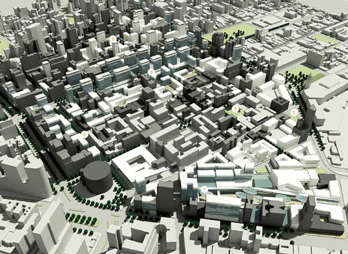
A number of goals were set by the Municipality to be achieved in the plan:
– Reinforce the existing commercial function of the region, with special attention for the technology sector, represented by businesses around Rua Santa Ifigênia;
– Diversify residential profiles (different family types, singles etc.), in order to create a heterogeneous environment;
– Restore degraded and obsolete areas to increase living quality;
– Increase the amount of public space used for squares and social interaction;
– Improve the general conditions of mobility and infrastructure of the region;
– Restore architectural heritage, cultural and artistic works in the area;
– Create a social environment that promotes social and economic development.


New profile of Avenida Rio Branco

The winning project presupposes the redevelopment of around two thirds of the existing buildings, whereas one third is to be maintained and restored. The plan divides the area into five sectors:
1. Nébias – reinforcing the existing residential and hotel functions;
2. Corridor Rio Branco – turning the somewhat fragmented avenue into a dense urban boulevard, served by public transport, with large office buildings on top of a retail base level;
3. Triunfo – creating a diverse residential area, with library, school, kinder-garden and services;
4. Nova Luz Culture and Entertainment area – transforms the direct surroundings of the station, mainly sheds and parking lots, into a leisure area;
5. Technological area – attracting lead technology businesses through tax incentives.


Triunfo sector – school and public space

Architectonic ambitions are high, judging by the illustrations of the plan. Buildings interact with the urban environment at ground level and have lively balconies and openings in the facades. Public space is very green and attractive, compared to earlier urban operations in the city such as the Berrini Avenue. A few observations have to be made:
Firstly, the project merely provides volumetric studies of the area and does not determine the exact urban form of the developments at this stage. Individual developers will offer their projects in following tenders. In the past, this has not always led to a desirable urban form and architectural quality in São Paulo. Developers tend to emphasize safety and privacy aspects, instead of interaction of the building with the street, as they fear that the building won’t sell if it is made too transparent and accessible. If investors don’t commit to the architectural ambitions of the urban plan, or when supervision of the plan fails, the quality of the whole plan is at stake.
Secondly, the quota of social housing units in the plan, as fixed in the Zeis municipal land use plan, must still be implemented through tenders. As this segment is less profitable than other types of dwellings, the social housing units tends to be unattractive for investors. Strict rules for mixed developments and application of fines when social housing is not delivered, could help to encourage the fast implementation of social housing in the area.


Sala São Paulo concert hall by night

Many of the buildings on the list to be demolished, have a social housing function today. NGO’s like Fórum Centro Vivo have been concerned with the current population and small businesses in the Nova Luz area, threatened by increasing real estate values and gentrification. In 2008, the NGO organized an informal night walk through Nova Luz with lanterns, Traga sua Luz, to point out the effects of demolishing in the area. Less than two years later, the offical Nova Luz project office organizes another night walk to show the beauty and potential of the cultural district, near the Luz train station. However, the photo report of the excursion shows mostly well known historic buildings situated outside the Nova Luz area, such as Teatro Municipal.

Read more:
Nova Luz SP project office
Nova Cracolândia (Portuguese)
Nova Luz in 2007 (Portuguese)

Sphinx

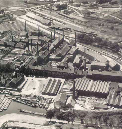
In 2004, the city of Maastricht approved the Belvédère master plan, concerning the grand scale redevelopment of an old industrial area, at the fringe of the old city center. The site is characterized by the old Sphinx factory (porcelain and ceramic products), as well as the central dock, where ships used to unload raw materials and load manufactured goods. Sphinx was founded in Maastricht in 1834 and its new owner, a Finnish businessman, ended activities in Maastricht in 2010.
The industrial complex intersects with two main urban structures of 19th century Maastricht: the military defense walls, surrounding the city, and the Willemsvaart, a major transport canal for importing and exporting goods. In the remaining buildings, several innovative building techniques of the industrial age were incorporated in an early stage, such as the reinforced concrete structure of Hennebique and one of the first glass curtain walls.

The master plan affirms Maastricht as a compact city in an open landscape. This means the Belvédère site is one of the last areas for large scale urban projects. The transformation will take between 20 and 25 years and will cost around 1,3 billion euros. The municipality has signed a joint venture for the investments with ING Real Estate and BPF, among smaller corporations. In the plan, there is a focus on new dwellings, offices and cultural program. In the light of the current European real estate crisis, these ambitions are likely to be altered or delayed.

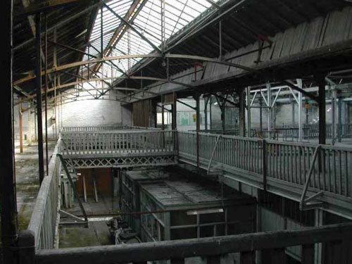
One of the icons in the industrial site is the Carpenter’s Workshop. The transformation of this old structure to give it an important cultural function is supposed to boost the cultural infrastructure of Maastricht. The complex shelters a cultural movie theater, studios for practice purposes and a performance theater for the Huis van Bourgondië, a workshop for music production house Intro-In Situ, a practice space for Toneelgroep Maastricht, a cultural café, a restaurant, lobbies and office space, space for urban music and events, a theater room with 400 chairs, artist lobby and technical space, and a bicycle garage.

Read more:
Report on the historic value of the Sphinx complex (Dutch)
Discover the Sphinx area Maastricht and its main buildings in Google Maps

Soho – Hong Kong

Soho, near the central district of Hong Kong Island,  is a dynamic urban area full of restaurants, shops and nightlife. The traditional hill-side neighborhood stretches more or less from the lower Queens Road Central until Robinson Road at the top, having the busy Hollywood Road in the mid level.
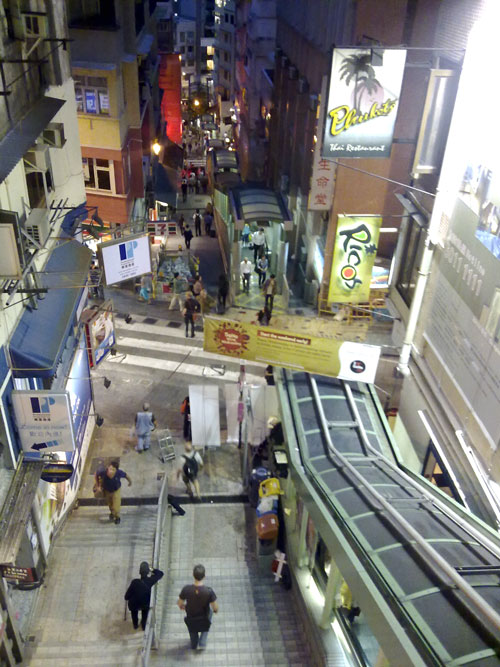
In the early nineties the Central-Mid-Levels Escalator System was built, able to move people up-hill over 800 meter distance and 135 meter level. The system has entrances at most streets. In the morning it descends, to help people in the neigborhood get to work quicker; at night it ascends, to get inhabitants back home and to bring people up to the bars and restaurants.


View of the Central-Mid-Levels Escalator

This easy access has triggered a rapid gentrification and increasing mixed use of the area. The direct surroundings of the escalator are completely dominated by tourist restaurants and fast food chains. Neighboring streets are steadily being occupied by luxurious apartments for expats and fancy art galleries. In some of the streets an interesting mix can be seen between new art galleries and traditional Hong Kong craftsmen workshops, but due to the ground prices this unique situation is unlikely to last long.


Art gallery and vintage shop in Soho


Wall graffiti in Soho

Explore Soho Hong Kong and the escalator system in Google Maps

Kowloon – a transformation

The central part of the city of Hong Kong lies on both sides of Victoria Harbour, on Hong Kong Island in the south, and the peninsula of Kowloon in the north. Kowloon still has traditional neighborhoods with lots of street markets and high-density urban blocks. The area of Mong Kok, in the middle of Kowloon, has one of the highest urban densities in the world, over 40.000 inhabitants per square kilometer. Real estate pressure is bringing massive office development from saturated Hong Kong island to Kowloon and is beginning to transform its waterfront.

At the building sites on reclaimed land west of Kowloon, one can see the rise of the new Kowloon. The integration of Austin metro station, Kowloon station (Airport Express line) and the new West Kowloon Express Rail Link Terminus (High Speed rail to mainland China) will turn this area into an international hub. Around Kowloon station, residential towers and offices are almost completed, including the 118 storey (484 m) ICC building. A few kilometers to the east, an equally large site will be developed at the old Hong Kong airport Kai Tak.